294
294
Dec 6, 2012
12/12
by
KPIX
tv
eye 294
favorite 0
quote 0
santa rosa approaching an inch and over an inch in san francisco. there you have that stat in oakland, as well. overnight tonight with the blanked of clouds numbers in the 40s and 50s. we'll see pockets of fog, as well. then we'll start to see the clouds gradually breaking up in the overnight hours leaving us with some areas of fog for tomorrow morning's commute. otherwise, we will have partly sunny conditions. wait until that you see seven- day forecast. first things first. pinpointing your neighborhood, 50s beaches. tomorrow for your thursday, 60s around the peninsula. jumping up to the low 60s as we swing around to the santa clara valley including willow glen, alum rock and alviso. east of the bay especially well inland topping off at 63, 46 degrees for the warmest locations. otherwise, 60 in walnut creek. this is similar to what we experienced today as far as our numbers are concerned, 60s in san francisco and kentfield. the extended forecast, nothing but sunshine and seasonal temperatures each and every day allowing us all to dry out just a bit
santa rosa approaching an inch and over an inch in san francisco. there you have that stat in oakland, as well. overnight tonight with the blanked of clouds numbers in the 40s and 50s. we'll see pockets of fog, as well. then we'll start to see the clouds gradually breaking up in the overnight hours leaving us with some areas of fog for tomorrow morning's commute. otherwise, we will have partly sunny conditions. wait until that you see seven- day forecast. first things first. pinpointing your...
288
288
Dec 5, 2012
12/12
by
KPIX
tv
eye 288
favorite 0
quote 0
widespread showers from santa rosa all the way down to santa cruz. we are looking at some heavy showers. and then rain moving out by tomorrow evening. then clouds move out thursday 1:00 in the afternoon mainly sunny. highs tomorrow with the rain around low 60s oakland 63, san jose 63, palo alto 62. you will have showers at times for pleasant hill, pittsburg, antioch, highs in the low 60s and a steady rainfall overnight and tomorrow morning for santa rosa. your high 61. san francisco 61 degrees tomorrow. once we're finished with tomorrow's rain, it is smooth sailing highs around 60. overnight lows chilly but we'll be sunny for six straight days after wednesday. that's your cbs 5 forecast. sports is coming up next. [ laughter ] [ girl ] wow, you guys have it easy. i wish i had u-verse when i was your age. in my day, we didn't have these fancy wireless receivers. blah blah blah. if i had a sleepover, i couldn't just move the tv into the playroom. no. we had to watch movies in the den because that's where the tv outlet was. and if dad was snoring on the
widespread showers from santa rosa all the way down to santa cruz. we are looking at some heavy showers. and then rain moving out by tomorrow evening. then clouds move out thursday 1:00 in the afternoon mainly sunny. highs tomorrow with the rain around low 60s oakland 63, san jose 63, palo alto 62. you will have showers at times for pleasant hill, pittsburg, antioch, highs in the low 60s and a steady rainfall overnight and tomorrow morning for santa rosa. your high 61. san francisco 61 degrees...
296
296
Dec 4, 2012
12/12
by
KPIX
tv
eye 296
favorite 0
quote 0
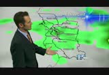
cooling off even with cloudy conditions santa rosa 54. and oakland right now 57. hi-def doppler is now showing a couple of very light showers moving onshore out to point reyes, santa rosa and healdsburg. you may get showers tonight and we'll be watching those showers moving in tomorrow especially and then also on wednesday. notice i'm saying showers and not rain. there's a reason for that. showers are just kind of intermitten not that heavy. rain is what you had yesterday and last friday and wednesday. i'm not expecting that this time. the atmosphere doesn't have as much water in it for this storm. an area of high pressure is building in off the southern california coastline taking the storm track, aimed right at us and moving it hundreds of miles to the north. very key because even an indirect hit makes a big change and we are not going to see that much rain from this particular system. so will we see rainfall? will all of us get more rain? we will starting tomorrow through wednesday but will it be a flood maker? no. heavy rainfall will stay away from this system
cooling off even with cloudy conditions santa rosa 54. and oakland right now 57. hi-def doppler is now showing a couple of very light showers moving onshore out to point reyes, santa rosa and healdsburg. you may get showers tonight and we'll be watching those showers moving in tomorrow especially and then also on wednesday. notice i'm saying showers and not rain. there's a reason for that. showers are just kind of intermitten not that heavy. rain is what you had yesterday and last friday and...
545
545
Dec 8, 2012
12/12
by
KPIX
tv
eye 545
favorite 0
quote 0
we will drop down to 39 tonight in santa rosa. watch out for fog in the valley in the north bay and east bay. the overall weather picture is a very pleasant one if you like sunshine and most of us do. we will have plenty of sunshine the next couple days. the reason why, the big dome acting like a bouncer not allowing any of these storms to get anywhere close to northern california. it is shoving it around the high pressure which means snow for washington and northwestern oregon but not for us. the storm track stays away. we will have chilly mornings with clear skies. highs well into the 60s all the way until tuesday of next week. that's how long we will be sunny as well. so, you will have morning fog away from the bit. next week we will see a pattern change but not until next wednesday. it will get a little cloudier, a little bit wetter, but much colder. enjoy the warm while you have it. average high, oakland, you normally hit 58 this time of year. instead, 63. concord, you're normally 53. tomorrow 61. san jose 63. redwood city, l
we will drop down to 39 tonight in santa rosa. watch out for fog in the valley in the north bay and east bay. the overall weather picture is a very pleasant one if you like sunshine and most of us do. we will have plenty of sunshine the next couple days. the reason why, the big dome acting like a bouncer not allowing any of these storms to get anywhere close to northern california. it is shoving it around the high pressure which means snow for washington and northwestern oregon but not for us....
273
273
Dec 7, 2012
12/12
by
KPIX
tv
eye 273
favorite 0
quote 0
santa rosa 50. oakland 60. traffic over the bay bridge trying to get into san francisco pretty bad outside right now. the metering lights are stil on. it's rained in the bay area the past 26 days. we are turning the corner. here's hi-def doppler. don't mind the green you see offshore. that's just some ground clutter. we are rain-free on the radar and will remain that way for a while. let's talk about tonight because we're going to get chilly especially in the north bay. santa rosa 41. napa 43. mid-40s with fog likely for concord, livermore. fremont 45. fairfield foggy toward travis air force base tomorrow at 44 degrees for your overnight low. what we're looking at right now is a high pressure. we have a lot of low cloud cover and fog in the central valley. that will be prevalent over the next couple of days and tomorrow morning especially, some of that fog will work its way back inland so watch out north bay and east of the east bay hills out toward the 680 corridor. you will likely be foggy tomorrow morning. t
santa rosa 50. oakland 60. traffic over the bay bridge trying to get into san francisco pretty bad outside right now. the metering lights are stil on. it's rained in the bay area the past 26 days. we are turning the corner. here's hi-def doppler. don't mind the green you see offshore. that's just some ground clutter. we are rain-free on the radar and will remain that way for a while. let's talk about tonight because we're going to get chilly especially in the north bay. santa rosa 41. napa 43....
 Live Music Archive
 Librivox Free Audio
 Metropolitan Museum
 Cleveland Museum of Art
 Internet Arcade
 Console Living Room
 Books to Borrow
 Open Library
 TV News
 Understanding 9/11